Introduction
Ground Penetrating Radar (GPR) is a powerful tool that can help us understand what lies beneath the surface. GPR works by sending high-frequency electromagnetic waves into the ground and measuring the reflections that bounce back. The frequency of these electromagnetic waves is in the same general range of frequencies used by cell phones. The reflections can reveal the presence of subsurface features such as pipes, utilities, geological formations, and a variety of buried objects.
Because GPR is a non-invasive geophysical method that uses electromagnetic waves to detect subsurface features, it has a wide range of applications in various fields. These include archaeology, geology, engineering, law enforcement, and glaciology. This post will go over the basics of what you need to know about GPR.
How GPR works

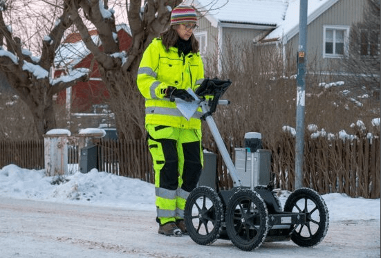
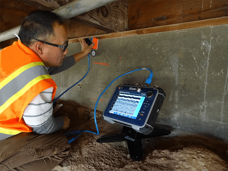
GPR instruments generally have two antennae: one for transmitting the radar signal, and one for receiving it. In most commercial applications, these antennae are contained in same instrument housing. This is often called a “monostatic” antenna configuration (though, technically, monostatic means there is only one antenna being used, but this is very rare in GPR). In most near-surface applications, monostatic GPR can be pushed along on a cart (see image above) or pulled on a sled. Often a GPS is used to locate the survey on the Earth and an “odometer wheel” may be used to measure precisely how far the GPR unit has moved to trigger measurements at even distances (for example, every 5 cm).
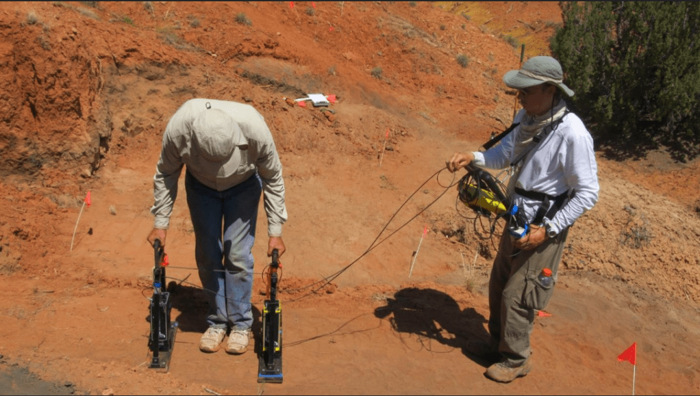
In a “bistatic” antenna configuration, the antennae are physically separated (see image below). Bistatic configurations allow for more flexibility but are more difficult to use and process. There are also GPR applications that use several antennae at once and may be tethered together (for example) on a trailer behind a vehicle. This allows for rapid, 3D acquisition of a large swath, but greatly increases the complexity of the processing.
There are many different kinds of GPR antennae configurations. In any case, the transmitter antenna sends out electromagnetic waves into the ground, while the receiver antenna detects the reflections that bounce back. A control unit processes the data collected by the receiver antenna and displays it on a screen.

The GPR signal is reflected back to the instrument primarily when the material changes. GPR is therefore very useful for finding objects and interfaces in the subsurface but may provide only limited information about the material itself. The physics of why GPR waves reflect is very similar to how light refracts and reflects through water, glass, and air. Water, glass, and air all have different properties with respect to how easily light can pass through them. In other words, water, glass, and air all have different electromagnetic properties, so light will reflect and refract off of them. GPR signals work in much the same way through geologic and other materials, and this makes it very useful in many different applications.
Applications of GPR
Some of the most common applications of GPR include:
Locating underground utilities
GPR signals tend to propagate well through man-made materials like concrete and sandy fill. These materials also differ electromagnetically from water- or air-filled pipes and pipes made of metal. Because these are relatively shallow, relatively continuous, and relatively different from the surrounding material, they make good targets for GPR.
Mapping geological features
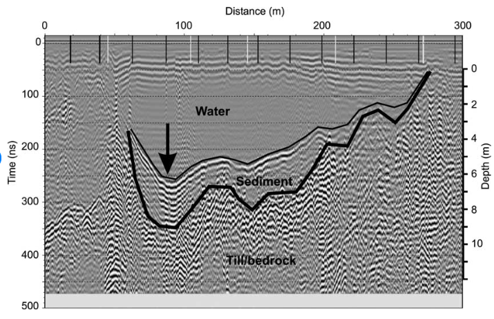
GPR can be used to map geological features such as bedrock and soil layers. Geologic materials vary immensely in their electromagnetic properties, and water differs greatly from most geologic materials. Because of this, geologic interfaces between sandy and clayey materials; unconsolidated and bedrock/lithified materials; and water and geologic materials can often be found easily using GPR.
Detecting buried objects
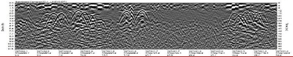
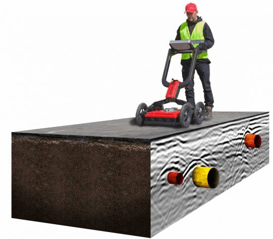
GPR can be used to detect buried objects such as artifacts and graves. GPR is therefore used in many archaeology and crime scene investigations sites. The objects and artefacts of interest in these fields often differ–even if slightly–from the surrounding geologic material, making them viable GPR targets. Ground that has been disturbed often has a different electromagnetic signature than intact ground. So, sometimes in these applications, it is not the object itself but the disturbed ground that allows GPR to be used effectively.
Non-Destructive Evaluation of Concrete Structures
GPR is used extensively by engineers to detect voids, cracks, and other weaknesses in concrete to assess the competence and strength of the concrete. This is often referred to as Non-Destructive Evaluation, or NDE. GPR for NDE is used in bridges, dams, columns, foundations, and other concrete structures, or may be used to evaluate the conditions beneath these structures (this is especially important with dams, since moving groundwater can erode beneath man-made structures). In many cases, GPR used in this way has saved lives and contributed to the closing or repair of dilapidated structures, as was the case for the Oroville Dam spillway in 2017.
Glaciology
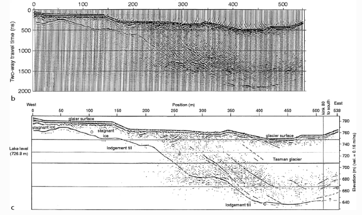
Because glacial ice is relatively consistent in its composition, GPR is able to travel through it without losing much energy. Then, when it hits the land surface below the glacier, it will reflect back a relatively large amount of energy. This is how we know that much of the land surface under the Greenland and Antarctic ice sheets are actually below sea level.
Advantages and limitations of GPR
GPR has several advantages over other geophysical methods. It is rapid, and completely non-invasive, meaning it does not require drilling or excavation. It is also highly accurate and can detect subsurface features with high resolution. A GPR survey can often be carried out with a small crew of 1-2 people. GPR processing is also a rather advanced field relative to the number of people that use it. This is because the GPR processing is very similar in many ways to seismic data processing, which is a multi-billion-dollar industry that has been developed in large part for use by the oil and gas industry.
However, GPR also has some limitations. It is generally only used in very shallow applications. It is less effective in certain soil types such as clay and wet soil. It also has limited penetration depth in highly conductive materials such as saltwater.
How GPR data is collected
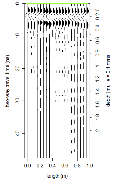
GPR data is usually collected as one-dimensional data. These data can be represented by a single “stream” of data from the surface down. It is usually collected with time on the x-axis and EM amplitude on the Y axis. Time is converted to depth using a known or derived velocity. These individual one-dimensional data streams are often collected one after another and strung together to make a 2D profile (See picture to the right, though the axes have been tilted to the side so that time/depth are on the vertical axis). These two-dimensional profiles can be displayed as a series of one-dimensional data (as in the picture to the right) or can be displayed as an image (i.e., the grayscale GPR data images shown in the previous sections). Sometimes only one-dimensional data is needed, and sometimes, multiple 2D profiles are collected together in a grid.
When data is collected as a grid, a 3D view of the subsurface can be derived through special processing techniques explained below.
How GPR data is processed
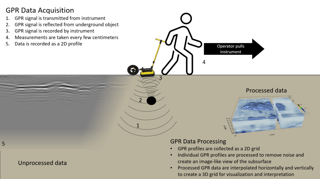
The data collected by GPR is processed using specialized software that converts the raw data into something that resembles an image of subsurface features based on the reflections detected by the receiver antenna. The software uses algorithms to filter out noise and remove the features (such as the hyperboles shown in the image in the Detecting Buried Objects subsection) that are part of GPR data acquisition, but which do not represent real objects or interfaces underground.
There are some common processing steps, and the order in which these steps are applied is not always the same. Common processing steps include:
- Time-0 Correction
- DC Drift removal
- Background Subtraction
- Migration
- Frequency filtering
- Deconvolution
- Gain application
- Hilbert Transform
- Depth slicing/2D & 3D Interpolation
Conclusion
Ground penetrating radar is a powerful tool that can help us understand what lies beneath the surface of the earth. It has a wide range of applications in various fields and offers several advantages over other geophysical methods. By following these guidelines for collecting and processing data using GPR, you can create accurate images of subsurface features that will help you make informed decisions in your work.
Further Reading
- What Can You Detect With Ground Penetrating Radar?. https://usradar.com/blog/what-can-you-detect-with-ground-penetrating-radar/.
- Ground-Penetrating Radar and the “Fringe:” Another Example. https://www.andywhiteanthropology.com/blog/ground-penetrating-radar-and-the-fringe-another-example.
- Can Drones Use Ground Penetrating Radar? (Explained). https://www.droneblog.com/can-drones-use-ground-penetrating-radar/
- How the ground-penetrating technology used to locate unmarked graves is …. https://www.theglobeandmail.com/canada/article-the-technology-used-to-search-for-lost-graves-is-amazing-and-murky/.
- Improving Road Conditions with Ground Penetrating Radar – SoftDig. https://www.softdig.com/blog/road-conditions-gpr
- How Does Ground Penetrating Radar (GPR) Work?. https://usradar.com/blog/how-does-ground-penetrating-radar-gpr-work/
- What Is the Effective Depth of Ground Penetrating Radar?. https://usradar.com/blog/what-is-the-effective-depth-of-ground-penetrating-radar/.

You must be logged in to post a comment.