- DEM: Digital Elevation model – any digital representation of any kind of elevation. Lidar can produce multiple DEMs in one pass
- DSM: Digitial Surface Model – the elevation map produced with primarily “first return” data. That is, a digital map of the first thing that the laser reaches. This usually includes objects like treetops, buildings, and bridges.
- DTM: Digital Terrain model – the elevation map produced primarily with “last return” data. That is, a digital map of the last thing the laser reaches before it reflects back to the source. This is usually intended to represent a “bare-earth” map that shows only terrain. Often, this is more highly processed than a DSM to remove or interpolate through things like trees, buildings, bridges, etc.
One of the basic things earth scientists do to understand the geologic past is to look at the geologic present. The shape of the Earth’s surface is one of the easiest ways to do this. We just happen to live on a planet where light and other electromagnetic waves can travel freely from the furthest reaches of space right to the surface. We can see the stars! After millions of light years of unimpeded travel, though, when light or other waves hit the surface of the Earth…they stop. Some of it the energy will reflect back up again, but the Earth’s surface is something of an impenetrable barrier.
This is why measuring the shape surface of the Earth is a relatively simple thing to do. It is the geophysical equivalent of hitting the broadside of a barn.
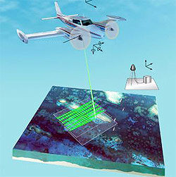
One of the most state-of-the-art techniques to measure the Earth’s surface is called lidar. Like radar, lidar has become its own word but originally stood for Light Detection and Ranging (LiDAR). For data related to landscape elevation, lidar data is usually collected using airplanes. The airplane flies back and forth collecting data in swaths until an entire area has been collected. Collecting such data from the air allows rapid collection of data and multiple types of data to be derived from the data.
Data is collected in something called a point cloud. A point cloud is essentially data points are arranged in space using their latitude, longitude (derived from GPS on the plane, the direction of the light beam, and control points on the ground), and the elevation (which is derived from the plane’s elevation and how long it took for the light pulse to travel to the Earth’s surface and return).
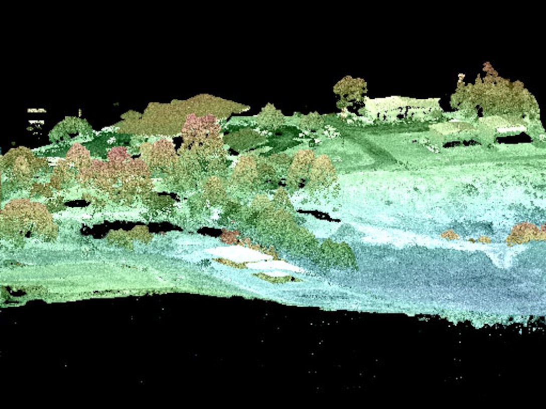
The laser beam used for lidar will reflect off the first object it hits. The measurement device in the airplane will sense a spike in energy when this laser first reflects back from the Earth’s surface (this is called the first return). This gets complicated, though, for objects like trees, where some of the laser’s energy will reflect back from the tree tops, and some of it will penetrate through to the ground and reflect back from the ground. This results in a second return (or even a third return, if there are intervening layers of the tree that also reflect back the laser). This complicates the data, but it means that we can get even more information out of a single laser beam.

The first returns can be used to measure tree canopy type. This can be very useful for things like understanding how much carbon is in a forest, or for mapping tree density.
The last returns are usually the ground surface. This is very useful for mapping things like geologic landforms. In fact, it allows us to see “through” tree and vegetation cover and better understand the underlying geology. This can be useful, for example, to map ancient landslides, where forest cover has obscured evidence of previously precarious slopes.
In short, the data collected using lidar can create multiple useful products. The most common of these are a Digitial Surface Model (DSM) and a Digitial Terrain Model (DTM). These are both types of Digitial Elevation Models (DEM), which is a more general term.
A Digital Surface Model (DSM) is usually produced using primarily first return data. It is a digital representation of the location of the first thing the light touches. It represents a similar set of objects to what we would see with our eyes from the air. DSM’s are still processed to remove outliers and noise and to ensure the geolocation is correct, but it is not processed to the same extent that at DTM is.
A Digital Terrain Model (DTM) is usually produced using primarily the last return data. It is a digital representation of the location of the Earth’s land (and water) surface. It allows us to “see” what is obscured by vegetation cover. It is a vitally important tool for geologists and geomorphologists around the world–not to mention engineers, surveyors, and other Earth scientists–since it gives clues to the underlying geologic forces at work in the past.
